写真:Kearsarge Pass北側斜面から望む南西方面Kings-Kern分水嶺の山並み(2枚張り合わせ写真)。
1864年夏、探鉱者のThomas Keoughらにより、インディアンが使っていたOwens ValleyとSouth Fork Kings Canyon(Kings渓谷)を結ぶKearsarge Pass(11,845ft.)を越えるルートにトレイルが作られました。7月末、South Fork Kings渓谷一帯を調査し終えたCalifornia Geological Survey(Whitney隊)のBrewer、Hoffmannらは、このトレイルを使いシエラの分水嶺を東側へ越えます。Owens Valleyを北上した一行は、Mono Pass(ヨセミテではなくLittle Lakes Valleyの奥の峠)で再びシエラを越え、西側Mt. Goddard周辺の調査を行なった後ワオナに集結、10月になるとClarence KingとRichard Cotterは、州立公園に指定されたばかりのヨセミテ渓谷へと入り、公園境界の測量を行うことになります。1873年及び1875年、友人と共にヨセミテからKings渓谷を訪れたMuir一行は、同様にKearsarge Passを越えてOwens Valleyに入ります。このときMuirはMt. Whitneyの登頂を3度試み、2度成功しました。Brewerは日記の中で(1864年7月27日)、Kearsarge Passからの風景を”the whole scene was one of sublime desolation”と、その荒涼さを書きとめています。一方Muirは、『The Mountains of California』(1894年)で、”Surpassing grandeur of scenery”と雄大さを指摘しています。両者の好みが分かれて興味深いところです。
前置きが長くなりましたが、Kearsarge Passからの景色は一見に値します。峠への上り口は標高9,200ft付近のOnion Valley THです。ここはIndependenceの町の395号と、Market Streetとの交差点からOnion Valley Roadを西に14マイル弱ほど進んだ行き止まりにあります。THからは、高度差約2,600ft.、片道5マイルの整備されたトレイルを、高度障害に注意してゆっくりと、途中の景色を楽しみながら数時間も歩けば峠にたどり着き、南シエラの荒々しい山並み、眼下に広がる深く削られた谷や、所々に散らばる青い湖を展望することが出来ます。余裕があれば、峠の北側の斜面をできるだけ上がってみましょう、登るほどに展望が開けます。

Kearsarge Pass:左側最高峰はMt. Brewer(13,570ft.)、右奥の谷はKings渓谷上流のBubbs Creek。

地図
Sierra Wildland Fire Reporting System
National Park Service、US Forest Service、BLM管轄区内での、山火事報告用のシステムですが、Live Camへのリンクがあります。”Real Time”のタブで”Web Cam”を選択すると、地図(最上)とカメラへのリストが現れます。
ブッシュ大統領、国立公園への予算増強
本日受け取ったY.A.からのEメールニュースに以下のような記事が出ていました。
シーズナルレンジャー(夏期限定の季節雇用)や道路や施設メンテナンスの充実が図られるようです。
ヨセミテ国立公園でも昨年度比13%アップの予算が組まれているということです。
—-
President Bush Proposes Budget Increase for National Parks
In his proposed budget last week, President Bush set aside $2.4 billion to help reverse chronic funding shortages in national parks. The money, a combination of public and private funds, would pay for a much needed increase in seasonal rangers and maintenance and construction. As part of this proposal, Yosemite could see as much as a 13% increase in funding over its 2006 budget.
Learn more by following the link below to the San Francisco Chronicle.
Photo by Bob Campagna
Read more… –
Big Pine Lakes
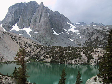
写真:Second Lakeから望むTemple Crag(左側の岩壁)とNorth Palisade(標高14,242ft.、Temple Cragの右奥)
Bishop Passから南東側に伸びるシエラの分水嶺は、14,000ft.級(約4,200メートル)の高峰を含む鋭鋒群で構成されています。これらはPalisade山群と呼ばれ、岩と雪の殿堂としてクライマーに人気のある一帯です。北東側の山麓には9つの湖を含む盆地状の谷があり、ハイキングルートが整備されています。アクセスは、Bishopの町からCA395号を14マイルほど南下し、Big Pineという小さな町のCrocker Streetとの交差点で曲がり、西へ14マイルほどGlacier Lodge Roadを進んだ行き止まりがトレイルヘッド(標高7,800ft.付近)になっています。ここからNorth Fork Big Pine Creekに沿って4マイル強ほど歩くと、湖を廻るループの分岐点に到着します。そこから左手の分岐を辿り、数百メートルを進むとFirst Lake(標高10,000ft.)に到り、Palisadeの山々が見え出してきます。ここまですでに2,200ft.を登っています、体力に合わせて廻る湖の数を決めてみてください。
”The most beatutiful mountain of these and one of the most beautiful in the Sierra is the North Palisade” Norman Clyde (1928)

積雪量
2月1日のTM付近での積雪量は、平均の43%との事です。今年は(現時点では)かなりドライな冬のようです。
Park Rangers recently completed the February 1 snow surveys. Overall, the Tuolumne drainage has 43% of average water content while the Merced drainage has 41% of average. Depths ranged from 40 inches of snow at Grace Meadow (14 inches of water) to 17 inches of snow at Tuolumne Meadows (5 inches of water). This is the driest February 1 survey since the early 1990s. (M. Fincher – 2/5/07)
South Lake
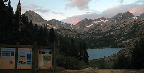
South Lakeトレイルヘッド
Bishopの町の中心部から西にのびるCA168号を15マイルほど進むと、South Lakeへの分岐が出てきます。ここを左折、7マイルほど進んだ行き止まりがトレイルヘッド(標高9,800ft.)になっています。South Lakeそのものはダム湖で、あまり風情はありません。そのため、岩に座り目の前に聳えたつ灰色の高峰やそれを映す湖面の風景を楽しむためには、樹林帯限界の標高10,700ft.付近まで登る必要があります。参考としては、分水嶺の峠Bishop Pass(標高11,972ft.、片道6マイル)、Treasure Lake(標高10,668ft.、片道3マイル)、Chocolate Peak山麓の周遊ハイキング(全6.5マイル)などが考えられます。ここもハイキング、バックパッキング、釣りを楽しむ人でかなりポピュラーで、シエラハイキング入門には最適な処といえます。このほかCA168の奥にはLake SabrinaやNorth Lakeなどのトレイルヘッドがあり、いくつものトレイルが整備されています。
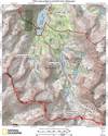 地図:South Lake付近
![]() Bishop Pass(右)まで1マイル地点から見るMt. Agassiz(13,893ft.)
Bishop Pass(右)まで1マイル地点から見るMt. Agassiz(13,893ft.)
ビジターセンター展示リニューアル中
なんだかよくわからないのですが、ヴァレーのビジターセンター展示コーナーがリニューアル中のようです。
近日〜春にかけて行かれる方、ぜひ写真つきでレポートをお願いします。
宛先:nishimura==yosemite.jp(==は@に置き換えて)
—
Visitor Center Exhibits
Wall mural installation is ongoing.
Electrical work will continue through the project
Rock sculpture installation is underway.
Floor finishing will continue through Feb. 5th.
Internal exhibit construction will begin Feb.5th.
ハイキングマップ
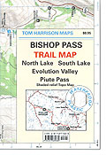
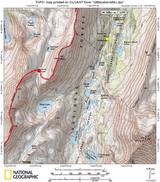
よくVisitor Centerなどで、写真のような地図を見かけます。折りたたんだ大きさは11.5cmX16.5cmほどで、耐水性のかなり丈夫な紙を使っています。ベースはUSGSの地形図ですが、それにトレイルが赤い点線で、区間距離と共にわかりやすく表示されています。ハイキングの計画にはかなり便利です。縮尺は1/47,520(1インチが0.75マイル相当)で、やや詳細に欠ける所もありますが、ハイキングの際には最低限携行したい地図です(できればUSGS1/24,000も共に携行することをお勧めします)。
Amtrakで行く冬のヨセミテ
サンフランシスコ・クロニコル紙に「Winter wonderland without all the winter driving worries
Amtrak’s Yosemite service makes sense during snow season」と題する写真入り紀行文が掲載されています。(1/14)
http://www.sfgate.com/cgi-bin/article.cgi?f=/c/a/2007/01/14/TRGSCNH2EN1.DTL&hw=yosemite&sn=003&sc=660
Little Lakes Valley
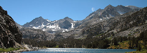
Little Lakes Valley(Long Lake)から望むBear Creek Spire(13,720ft.)、Mt. Dade(13,600ft.)、Mt. Abbot(13,704ft.)
Mammoth Lakesの町から395号を南に15マイルほど行き、Tom’s Placeという出口でハイウエイを降り、Rock Creek沿いの道路を10マイルほど登った行き止まりにMosquito Flatトレイルヘッドがあります。標高は10,300ft.とかなり高めですが、この先Little Lakes Valley(南西方面)に向かうトレイルにはほとんど上りがなく、4000メートル級の高峰に囲まれた美しい谷のハイキングを手軽に楽しむことが出来ます。トレイルヘッドから0.5マイルほどのところにある分岐を右に辿れば、3マイル強ほどで、標高12,000ftのMono Pass(ヨセミテのMono Passとは別)に達することが出来ます。峠は白い広大な砂地になっており、一種独特の雰囲気がありますが、展望はあまりききません。体力・経験に合わせて近くのMt. Starr(標高12,835ft.)に登るか、Ruby Lakeへ分岐から始まるスイッチバックを上りきった付近(景色が一番いいあたり)で引き返す、もしくはRuby Lake(標高11,121ft.)湖畔で遊ぶオプションが考えられます。このトレイルヘッドの駐車場はシーズン中にかかなり混み合います。満車状態のときは、かなり離れたところに(1キロ以上)車を停めて道路を歩くことになりますので、朝早く行くことをお勧めします。
