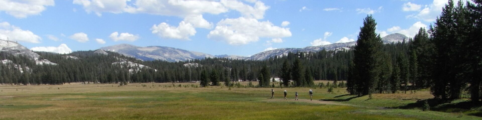
2月1日の積雪状況です。シエラネバダではすでに平年比90~130%となっており、去年の4月1日の積雪量を越えています。
全く無責任な予想ですが、今年の5月下旬Tioga Road開通は厳しそうです。
過去のデータ一覧は此処です。
カテゴリーアーカイブ: データ
ヨセミテ国立公園の入園料(改訂)
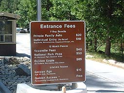
入園料は国立公園のゲートでレンジャーから徴収されます。国立公園の管理運営に必要な経費です。にっこり払いましょうね。
支払いと引き替えにもらうレシート(もしくはパス)は、帰路ゲート出場時にチェックされることがあるので、紛失しないようにしましょう。
またゲートは24時間オープンしていますが、夜間にはレンジャーが不在となります。その場合の入場料はビジターセンターにて支払うか、帰路ゲート出場時に支払います。
●自動車での入園(1台につき)
$20 7日間有効
●個人での入園(1名につき)
$10
バス、徒歩、自転車、バイク、乗馬での入園。7日間有効
■年間パス
2007年から従来の「ナショナル・パークス・パス」にかわり、全米の国立公園(国立史跡など国立公園局管理施設含む)および国有林など国立のレクリエーショナル・エリアで使用できる「America the Beautiful」の年間入園パスが発行されています。
詳細とオンラインでの販売はUSGSのサイトから。
ヨセミテのようにクルマ1台単位での課金がされるところでは、1台(つまり同乗者含む)に対して有効。また1人単位での課金がされるところでは、本人とその配偶者、子ども、親までが有効。
★「ヨセミテ・パス」
$40
ヨセミテ国立公園で1年間有効
★「National Parks and Federal Recreational Lands Annual Pass」
$80
全米の国立公園および国立レクレーショナルエリアで1年間有効
★「シニア・パス」
$10
62歳以上の合衆国市民権保持者対象。
★「アクセス・パス」
無料
障害をもつ人、公園内居住者対象
過去の道路開通日データ(タイオガロード)
待ちきれない方もおられるのですが、参考までに1980年以降の過去のタイオガロード開通日、閉鎖日のデータです。
近年における最も早い開通日は1988年の4月29日です。また昨年、一昨年がそうでしたが6月下旬にずれ込んだ年も数回ありますね。
地球温暖化の影響で今後開通日は早くなるかというと、決してそうでもないと思います。3月後半や4月になってから、まとまった量の降雪があった年は除雪作業が遅れます。つまり気候パターンの変動が要因とみたほうが良いのでしょう。
Year / Opened / Closed
1980 June 6 Dec 2
1981 May 15 Nov 12
1982 May 28 Nov 15
1983 June 29 Nov 11
1984 May 19 Nov 8
1985 May 8 Nov 12
1986 May 24 Nov 29
1987 May 2 Nov 13
1988 April 29 Nov 14
1989 May 12 Nov 24
1990 May 17 Nov 19
1991 May 26 Nov 14
1992 May 15 Nov 10
1993 June 3 Nov 24
1994 May 25 Nov 10
1995 June 30 Dec 11
1996 May 31 Nov 5
1997 June 13 Nov 12
1998 July 1 Nov 12
1999 May 28 Nov 23
2000 May 18 Nov 9
2001 May 12 Nov 11
2002 May 22 Nov 5
2003 May 31 Oct 31
2004 May 14 Oct 17
2005 June 24 Nov 25
2006 June 17 Nov 27
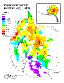
ヨセミテ 今年の積雪量
今年のヨセミテ・ハイシエラの降雪量は平年の50%といったところです。去年は150%くらいだったと思います。
http://cdec.water.ca.gov/cgi-progs/reports/COURSES.html
http://cdec.water.ca.gov/snow/
2006 Tioga Road除雪ログ

5月1日
* Tioga road progress May 1, 2006 – Today, we were able to begin the opening of Tioga Road. Crews made it to Gin Flat. Snow depth is approximately 5 feet and the snow is very wet and heavy. They found three trees buried in the snow, one of which was over 24″ in diameter.
* Glacier Point road progress – No progress report was submitted for Glacier Point road which also started today.
5月2日
* Tioga road progress – May 2, 2006 Plowing operations have reached Big Meadow Overlook. The snow depth is now 7 feet with very dense snow. We have run in to 8 buried trees, some over 24 inches in diameter, that had to be removed so plowing could continue. Our hope is to reach South Fork by Thursday.
* Glacier Point road progress – May 2, 2006 One half mile from Badger Pass. Snow depth is approximately 7 feet. All is going well.
5月4日
* Tioga Road progress:
Ending location: At South Fork Bridge
Snow depth: 8 Feet
Very heavy snow pack, encountered 8 trees with average size of 18-24 inches. We are now at the first avalanche zone. We are expecting to plow through this first zone early in the morning. If the temps go up considerably, crews may be forced to come back West of the zone until the temps drop or the slope stabilizes.
* Glacier Point progress:
Ending location: .8 miles from Badger Pass
Snow depth: 7 feet
Slow progress with rotary due to snow depth and high water content.
5月5日
* Tioga Road:
Started at South Fork Bridge and ended in the middle of Avalanche zone 1. Snow depth is approximately 6 feet. Quite a bit of rock and trees down in the avalanche zone. Will continue through the zone tomorrow.
* Glacier Point Road:
Still under a mile from Badger. No progress today. Loader mounted rotary broke down and needs to be taken to the shop for repairs.
5月8日(朝の報告)
3マイル強も進んでいます。8,000ft.地点は地図からプロットしたものですが、White Wolfへの分岐のすぐ近くのようです。去年のペースを追い抜きそうです。
*Tioga Road:
The crew was able to plow 3.3 miles today. They are now at the 8000 foot marker. Average snow depth is 10 feet. They encountered 5 trees, 3 over 36″ diameter and 2 over 24″ diameter.
*Glacier Point road:
No report (though, they were able to get going again with the help of one of the rotaries from Tioga Road).
May 8, 2006
*Tioga road progress
The progress today was only 1/2 mile due to equipment breakdowns. Snow depth was 10 feet. We are approximately 1 1/2 miles from White Wolf.
*Glacier Point road progress
Crews have gone up the road a total of 2.3 miles. Snow depth is approximately 5 feet.
May 10, 2006
除雪開始日は、去年より2週間ほど遅れましたが、White Wolfには3日ほど早く到達しました。ここから分水嶺までの2マイルは、北向き斜面で一番雪の深いところです。
GP roadは、約三分の一を除雪。
*Tioga road progress – May 10, 2006
Ended the day at White Wolf. Snow depth is 10 feet
*Glacier Point road progress – May 10, 2006
Crew has now gone 3.2 miles from Badger. Snow depth is 4 feet. No major problems.
May 11
*Tioga Road:
Total progress today was only 1/2 mile. The snow is 10 feet deep and very hard. This is normal progress in the area they are in.
*Glacier Point:
No work on the road today. The crews were diverted to patch potholes on the Wawona Road. Work will resume Monday.
May 15
*Tioga Road:
Saturday, the crews finished the day at approximately 16 miles in from Crane Flat. Snow depth is 11 feet. No major problems. Progress is slow due to the deep and heavy snow.
*Glacier Point:
No work on the road today. The crews were diverted to patch potholes on the Wawona Road. Work will resume Monday.
White Wolfより2マイル進んだようです。分水嶺の付近でしょうか。
May 17朝のポスト
月曜(15日)には3.3マイルも進み、Yosemite Creekに達しました。火曜(16日)には、橋から先の登りの斜面に入っています。GPも残すところ3マイル強くらいです。今週末までにGPに届けば、5月末(連休前)のオープンがあるかもしれません。
*Tioga Road progress May 15
Great progress today. The crews are now at Yosemite Creek Campground. They were able to plow 3.3 miles. The average snow depth is now down to an average of 5 feet. Tuesday, May 16 they start going up Yosemite Creek grade. This will be a slower process and will be entering the Yose Creek avalanche zone.
*Glacier Point Road:
Great progress here too. The Wawona crew was able to plow a total distance of 4 miles. They are now 7.2 miles in from Badger Pass. The average snow depth has dropped to only 3 feet.
May 17夕方のポスト
Tioga Roadは進まなかったようですが、GP Rd.はSentinel Domeが目の前です。あと0.3マイル弱も進めば、道路は一気にGPへと下り始めます。金曜には(とりあえずの)除雪が終了しそうです。
*Tioga Road:
Only plowed 1/2 mile today. Had to stop at the Yosemite Creek avalanche zone. Too late to go on through the zone. Will try to get an ambulance and plow through Wednesday May 17.
*Glacier Point Road:
The road crew is now 8.5 miles from Badger Pass, at Taft Point /Sentinel Dome parking area.
May 18夕方のポスト(17日の記録)
GP Rd. :Washburn pt.に到達。開通予定26日
*Tioga Road
The crew was able to plow through avalanche zone 9 today. They are now 21.1 miles in from Crane Flat
*Glacier Point Road
Today, they made it to Washburn Point. The goal of the crew is to make it to Glacier Point sometime late tomorrow. They will now have to go back and widen the road, do ditching, pot hole repair, and remove one big boulder that is in the road. The road may open to the public with limited services on May 26
May 18の記録
Tioga Rd:Porcupineキャンプ場(道路左側)への下りに入りました。去年は同地点に、5月23日に到着しています。
GP Rd.:GPに到着。道路の整備の後、来週後半に開通のようです。
May 18
*Tioga Road progress:
Plowing operations have now gone 22.4 miles from Crane Flat. They are now going down toward Porcupine Campground. Snow depth is approximately 8 feet. They are now encountering more rocks in the snowpack and have had to remove two buried trees.
*Glacier Point:
They have reached Glacier Point. They are now in the progress of cleaning the parking lots, patching potholes, removing a large boulder from the road, ditching, and sweeping. Forestry crews are also working up on the road. There are quite a few trees that need to be removed along with brushing operations. The road will be open to administrative traffic Monday and barring any problems, should be open to the public by some time late next week.
May 21
Tioga road progress – May 21, 2006The road crews are about 1/2 mile from Olmstead.The following is the latest observation by the Avalanche Team.What’s ahead Zones 10, 11, 12, and 13 should not be issues. Olmstead is and will continue to be a problem for sometime to come. We have accomplished only one explosives blackening op due to the continuing warm temperatures and high hazard. This operation was accomplished from above the slab with the use of ropes. It was very successful in removing a large area of concern but this process is pretty time consuming and there are many times this area of thick snow left to deal with. At this time it is uncertain if it will be safe for the crews to plow through when they get to Olmstead. The weather forecast calls for much cooler temperatures next week, so we may get a break for plowing and for blasting.
除雪はOlmsted Pt.に到達しています。明日の朝5時半、雪がしまり雪崩の可能性が無ければ、一気に除雪を試みるようです。27日にはヨセミテクリークまでの部分開通の可能性がありそうです。[註:うまくすれば、6月早めにTuolumneまで開通するかもしれません]
GPは25日(木曜)開通の予定。
108号の除雪状況にも要注意です。5月の第一週にSonora Passの麓(26.4 MI EAST OF STRAWBERRY )に達していました。連休前に峠が越えられるようになるかもしれません。
May 23
*Tioga Road:
Due to the high avalanche danger at Olmsted, the crews were not allowed to plow through this zone. Wednesday morning, they are going to attempt to plow through starting at 0530. If there is a good freeze up there tonight, they will be allowed to plow through the zone. Today, the crew worked at widening the road from White Wolf to Olmsted. We hope to have segment 2, from Walker Party to the Yosemite Creek Bridge, open to the public by Saturday May 27.
*Glacier Point road will be open to the public starting early Thursday, May 25th.
May 30
The crew is now at Tenaya Lake and is trying to go past the avalnche zone at Pywiack Dome. If they get through the may be in the meadows very soon.Glacier Point road is open.
May 31
除雪隊Tuolumne Meadowsの西端に到着。 Mono側は未だ除雪を開始していなかったようですね。
Olmsted Pt.の斜面は、未だ雪崩の危険があるようです。
The road crew is now up to the West end of Tuolumne Meadows. Snow depth is approximately 4 feet. Mono County is scheduled to start plowing into the park June 1st. Olmsted avalanche zone is still a very active and dangerous avalanche threat. (J. Cyr – 5/31/06)
June 1
雪崩危険地帯の状況が開通日を決めそうです。やはり17日付近でしょうか。
Today, the road crew will be going through the Dana Meadow avalanche zone. Once this is completed, the road will have been plowed to the Tioga Gate. Although they have reached the gate, there is still quite a bit of work to be done. The road needs to be widened and repaired. There are still five active avalanche zones, Dana Meadow, Marmot Dome, Olmsted, Spring Hill, and Yosemite Creek. We are hoping to be able to allow admin traffic to the meadows by Monday or Tuesday. All personnel that will need to go up on Tioga road will need to have been avalanche trained and certified. We hope to have White Wolf road plowed by late Saturday. There is no projection as to when the road might open. All is dependent on the Avalance zones. I will keep you all posted as things develop. (J. Cyr – 6/01/06)
6/6/2006
雪崩トレーニングを受けたパークスタッフは、今日からTioga Roadに入れるようです。
Tioga Road will be open today to Administrative Employees who have completed the avalanche training only. (R. Soden – 6/6/06)
NPS
The Tioga Road opened for the 2006 season on Saturday, June 17.
公式サイト地図。
2005年のログ。
Tioga Road除雪開始日: 5月1日
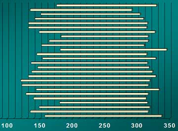
1980年から2005年までの26年間のTioga Road開通・閉鎖日グラフ。一番下の棒は1980年。一番上は2005年。横軸は1月1日から数えた日数で、1グリッドは10日。5月31日は151もしくは152日目にあたります。開通が一番遅れた年は1998年で7月1日。閉鎖が一番早かったのは2004年で10月17日。
除雪開始日が5月1日との発表がありました。
5月中のTioga Road開通の可能性は99%ないと思われます。6月末(独立記念日前)の開通を目指すといったところでしょうか。
高地での雪の状況は:
Spring has been very wet and snowpack at the higher elevations is very deep (109 inches at Tuolumne Meadows as of April 5; the snowpack hasn’t been this deep there in April since 1983). Snow has also fallen at the lower elevations, however the snowline is between 5,000 and 6,000 feet.…
と、1983年以来の雪の深さだそうです。ちなみに1983年のTioga Road開通日は6月29日でした。
2005年(去年)のGPとTioga Rd.の除雪の記録を再掲載
今年の開通日予測の目安になると思います。去年は意外と早くGP rd.が開いたんですね。
マーセド川の水量
USGSのサイトから、マーセド川の「POHONO BRIDGE」(ヨセミテヴァレー出口付近)観測地点の流出量データを一年分さかのぼって表示させてみました。青色線が今年の流出量(立方フィート/秒)、茶色線が平年(過去88年の平均)です。今年は概ね平年を大きく上回っていて、10月の今なお平年の倍近くあり、この流出量は平年の9月上旬位に相当します。
今年カリーヴィレッジのボートラフティングのレンタルは6月5日開始の予定でしたが、水位が高すぎて(ボートが橋の欄干をくぐれない程)ずいぶん開始が遅れ、また営業終了も「いつのまにか?』でした。(すみませんニュースを見落していたのかなぁ?。ご存知の方はコメントに記入してください。)
Merced Riverの水量
掲示板のほうで、ラフティングについての質問が出ましたので、マーセド川の現在の流量を調べてみました。洪水にもなった5月下旬から比べると8分の1ほどになっています。
USGS Real Time Water Data
例年ですと8月にはもう水位がだいぶん低下してラフティングの営業が終了してしまうのですが、2003年シーズンは水位が長持ちして9月のレイバーデイまで営業していました。今年はいつまでいけるでしょうか。
Merced Riverの水量
先週の洪水の時には及びませんが、かなりのものです。
USGS Real Time Water Data
Backpacker誌アンケート
Backpacker誌2005年2月号(今月号)に読者(2,113人, 男性79% 女性21%)
へのアンケートの結果がありました。Yosemiteがらみでは
– Favorite National Park: 1. Yosemite 2. Glacier 3 Yellowstone
– Best View Point: 1. Half Dome 2. Angels Landing (Zion) 3, North Rim (Grand Canyon)
– Top Outdoor Photographer: Ansel Adams
– Top 3 Rock-Climbing Destination: 1 Yosemite 2.Grand Teton 3 Joshua Tree
でした。 Yosemiteに関係ありませんがDream Hiking Partnerは
Angelina Jolie(Tomb RaiderでLara Croft役)とのことです。