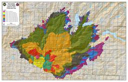
Greenは28日、赤は今日30日のデータ。
Merced、Tuolumne Glove、Crane Flat、Crane FlatからTioga Rdを4マイルほど上ったGin Flat。
マーカーT5、右側に滝の見えるところをプロット。

月: 2013年8月
Rim Fire(8/30)
InciWebページの右端中ほどにIncident Perimetersの欄があり、火災の広がりの状況がGoogleEarthで読み込め、オーバーレイできます。
http://inciweb.nwcg.gov/incident/3660
以下はBofエントランス、120号とHetch Hetchyへ向かうEvergreenの交差点、
EvergreenとOld Tioga Roadの交差点、Aspen Valley、White Wolfを28日のデータとともにプロットしたものです。fire lineはおおよそOld Tioga Roadに沿っています。
[Old Tioga Road(未舗装)は、EvergreenからAspen Valleyまでは許可のある車両のみ通行できますが、そこから東側White Wolfeまでは廃道化しており、沢にかかる橋も落ちています]。
下側、小さな写真のアイコンが多く見られるところが現在のTioga Rd.が走っているあたり。緑の線はTuolumneとMariposa郡の境界(TuolumneとMerced水系の分水界)。

Rim Fire(8/29)
RIM FIRE INFORMATION
Update #19
Release for Wednesday, August 28, 2013/Time: 6:30 PM
Incident Statics
Acres Burned: 192,466 (301 square miles) Structures Threatened: 4,500
Containment: 30% Structures Destroyed: 111
Fire Start Date: August 17, 2013 Injuries: 4
Fire Cause: Under Investigation Total Personnel: 4,537
Cost to date: $39.2 Million
4500+まで増員されています。firelineは30%ほど(先週末は5%?7%)。
Bofエントランスのすぐそばまで火が迫っているようです。
Tuolumne水系の公園西側、ヨセミテクリーク西側、Mt. Hoffmann西側は閉鎖されています。
http://www.nps.gov/yose/planyourvisit/upload/rimfireclosure-082713.pdf
よく使われる”Contained/Containment”について
How Do You Rate a Forest Fire?
Chris Suellentrop
Posted Wednesday, Aug. 15, 2001, at 5:03 PM ET
Most of the news stories about the 43 large wildfires in the Western United States report some level of “containment” reached by firefighters. What does it mean to contain a fire, how is the percentage calculated, and when is a fire “controlled”?
To prevent a blaze from spreading, firefighters dig a “fire line” around its circumference. If three miles of fire line have been built around a fire that is 10 miles in circumference, then 30 percent of the fire is contained.(外周10マイルの火事に対して3マイルのトレンチなどのFirelineが作られると30%conainedされたという)
Fire lines are trenches dug to create a “fuel break” around the fire. Fires need fuel, oxygen, and heat to burn, and the easiest of the three to eliminate is fuel. Fire lines can also include “natural” barriers such as roads, rock bluffs, or streams.
Once a fire is fully contained, firefighters work on “controlling” it by battling it inside the containment line. A controlled fire is one that has no risk of expanding beyond the fire line.
RIM FIRE(8/28)
にしむら@ヨセミテ大好き!です。
ただいまTuolume Meadowsに滞在中です。
Toshiさんから投稿のあったRIM FIREですが、ここからも西方面に煙が見えており、かなり大規模です。
120号線は閉鎖中で、今回は140号を使ってヨセミテヴァレーを経由して来ました。
ヨセミテヴァレーには煙は入っておらず、視界はクリアーでした。
と、かいているうちに
Beginning at noon on Wednesday, August 28, the Tioga Road (Highway 120 through the park) is closed from Crane Flat to Yosemite Creek. The only access to the Tuolumne Meadows area is via Highway 120 from near Lee Vining.
明日から、Tioga roadがクローズです。
Tuolmune Meadowsから120号で帰れません!
Rim Fire(8/27)
8月17日、GlovelandのForest Service Ranger station の北東、Tuolumne Riverの北岸付近で始まった火災は22?23日にその勢いを増し、Hetch Hetchyのダム付近まで迫ってきました。

火は、Ranger Stationの東からBOFのエントランス手前(Hetchy Hetchyへ向かうEvergreeen Rd.の手前)の間で、120号を南側に超えています。Buck MeadowsのWest Gateモーテル付近は火災から逃れているようです。
http://www.inciweb.org/incident/3660/
公園内の状況:
バレーにはあまり煙も入っておらず特に規制はないようですが、火事に近い方面では、道路、キャンプ場、トレイルの閉鎖がされています。
http://www.nps.gov/yose/planyourvisit/rimfire.htm
Most of Yosemite National Park is not affected by the fire and is relatively smoke-free. The northern part of the park, including some areas along the Tioga Road, has some smoke. Conditions may change if winds shift.
However:
The Big Oak Flat Road (the continuation of Highway 120 inside Yosemite) and Highway 120 west of Yosemite are closed between J132 near Buck Meadows (outside the park) to Crane Flat Campground (inside the park). If you are trying to get to Yosemite from the west, use Highway 140 from Merced. You may also enter Yosemite via Highway 41 from the south and 120 from the east (Tioga Pass).
Hetch Hetchy Road and Evergreen Road are closed.
White Wolf is closed, including the lodge, campground, road, and trails originating from White Wolf. This area is closed due to smoky conditions.
Crane Flat, Hodgdon Meadow Campground and Hetch Hetchy Backpackers’ Campground are closed.
Merced and Tuolumne Groves of Giant Sequoias are closed so firefighters can work on preventive fire suppression efforts. The groves are not currently in imminent danger.
Wilderness trail closures: The area west of the May Lake Road and May Lake Trail continuing to the junction with the Pacific Crest Trail (PCT) at Glen Aulin and then north along the PCT to Bond Pass is closed. The park’s boundary serves as the closure’s northern and western edge extending south to Crane Flat Campground. The closure boundary continues east along the Tioga Road (Highway 120 through the park) to the May Lake Road. The Tioga Road and the trails serving as the eastern boundary of the closed area (including the PCT) remain open. May Lake High Sierra Camp, Glen Aulin High Sierra Camp, and Porcupine Flat Campground are open. View a map showing the closure [1.2 MB PDF].
Fire restrictions: No smoking and no building, maintaining, or using a fire, campfire or cooking fire (including charcoal fires) within the Yosemite Wilderness and potential wilderness additions. Portable stoves using gas or pressuring liquid fuel are allowed. Alcohol and Sierra stoves are not allowed. Campfires may still be used in designated campsites at designated campgrounds in non-wilderness areas within the park.
All other roads and areas are open. Yosemite Valley, Glacier Point, Wawona, Mariposa Grove, and Tuolumne Meadows areas are all open. Campgrounds in Wawona, Bridalveil Creek, Yosemite Valley, Porcupine Flat, and Tuolumne Meadows are open.
ハーフドーム・ハイカーズ・クラブについて
「ハーフドーム・ハイカーズ・クラブ」に久しぶりに入会(登頂報告)がありました。
許可制になって以来、許可を得ること自体がなかなかの難関になっているようです。
詳しいレポートもいただいております。
HIDE & ERIさん、ありがとうございました。
SFベイブリッジがクローズ(8/28-9/3)
8月28日から9月3日の間、SFベイブリッジが工事のためクローズです。
この時期にサンフランシスコ市内方面からヨセミテに向かわれる方、戻ってこられる方、ご注意ください。(私、ちょうど帰りの日程がぶつかってしまいます)
マイカー、レンタカーはもちろん、バスツアーもサンマテオ橋への迂回コースを使うことになると思われます。
http://baybridgeinfo.org/closure
BBSのURL変更
管理人のにしむらです。
いつも「ヨセミテ国立公園大好き!」をご利用いただき、ありがとうございます。
すみませんが、勝手ながらBBSのURLを変更したしました。
左のバナーからお入りください。ブックマークされておられる方は変更をお願いいたします。
また、ご質問やヨセミテのご報告、最新情報などお待ちしております。
