Muirの自然保護運動(続き): 1890年10月1日にヨセミテ一帯を国立公園にする法案が通過すると、Mariposa、Tuolumne、Mono、Fresno郡の人々は、自分たちの税収源が突然失われてしまった事に気づきました。また山岳地帯で自由に放牧をしていた牧畜業者たちは、一帯が突然閉鎖されてしまった事に反対していました。やがて新聞記事、牧畜業者や林業者組合の会合などで反対意見は勢いづき、1891年1月末には連邦議会への嘆願書が出されるに到ります。
このような中、1892年2月10日、連邦下院議員のAnthony Caminetti(元カリフォルニア州の議員)は、鉱山、牧畜、林業者らにとって重要な一帯を、ヨセミテ国立公園の境界から除くための法案HR5764を農務委員会に提出しました(しかしながらCaminettiは、自然資源の保護の重要性も理解しており、脚下されたものの、1892年5月26日には、ヨセミテ国立公園の保護のために1万ドルの予算をつける予算修正案を申請したり、前述HR5764で、ヨセミテ国立公園の湖沼に農務省長官の裁量で魚の放流ができるという項も付加していました)。
同じ頃、内務省長官Noble(R. U. Johnsonとは1890年10月以来書簡のやり取りがある。1891年6月には二人はYale大学より名誉称号を授与されている)は、議会で前年度(1891年)の年次報告をし、夏の間ヨセミテ国立公園をパトロールする第四騎兵隊(Saf Francisco、Presidioが駐屯地)I中隊長のWood大尉(ヨセミテ国立公園長代理)の推薦に基づき、公園境界の見直しを推薦します。Muirは3月24日にNoble宛に手紙を出し、境界の縮小案に賛成の意を表明します。一方、チャーターメンバーのJames Mason Hutchings(Muirがヨセミテに住んでいたとき働いていたホテルの経営主)やJohn T. McLean博士は、同月25日と26日に同じくNoble宛に強固に反対する手紙を出します。特にHutchingsは、更にMt. DanaとMt.Warren一帯(T1N/R25E)を公園に取り込むことを推薦しています。
6月に結成されたばかりのシエラクラブは、10月1日にOlneyの事務所で理事会を開き、クラブとして活動を開始することを決めます。2週間後に開かれた総会では、Caminetti法案の説明がされます。Caminetti議員は、11月5日の総会に出席し、Olneyとディベートをする予定でしたが、これは都合で実現できませんでした。そして、このときクラブは、法案反対の請願書を連邦議会の農務委員会へと送る事で決議しました。当時の理事会の議事録は、1906年のサンフランシスコ大地震の火災で焼失しまい、前述のMuirの境界変更への賛成意見が自分で取り下げられたのか、他のメンバーに押し切られたのかは不明ですが、最終的には境界変更を全く認めないということで嘆願書は作成されました。反対の主な理由は以下の通りです。
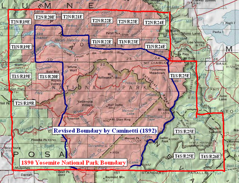
[1]T4S/R25、T4S/R25E、T3S/R25E(地図右下の三区画)はSan Joaquin川の重要な水源地帯である。[2]T1S/R19E、T2S/R19E、T1S/R20E(地図中央左の三区画)は重要な森林地帯でまたTuolumneとMercedのセコイアグローブもある。[3]T1N/R19E、T2N/R19Eは州の水源地帯として保護されるべきである(現在はEleanorとCherry湖が出来ている)。[4]T2N/R20EとT2N/R21Eの上半分、T2N/R22E、T2N/R23E、T2N/R24E、T1N/R22Eの上半分、T1N/R23Eの上半分、T1N/R24E、T1S/R25E(残りの地図上側の区画)はTuolumne川の水源地帯であり、Hetch-Hetchyを含む一帯は、将来重要な観光地になることが考えられる。
1893年2月、Caminetti案が農務委員会の議題に上ることを知ったR. U. JohnsonはMuirに電報を打ち、シエラクラブとして抗議することを求めます。2月6日、Muirは委員長宛に”The Caminetti bill is in favor of sheepmen and timbermen chiefly the latter. We urge delay until the light shines”と電報を送りました。これがどう影響を与えたのかは定かではありませんが、まもなくCaminetti案は委員会内で消滅してしまいました。
しかし翌1894年8月1日に、Caminettiは大統領の許可があれば、議会の承認なしに内務省長官が、その裁量で公園の境界変更が出来るという法案(HR7872)を公地委員会へ提出します。すでに長官Nobleは、1893年3月にHarrisonからClevelandへの政権交代に伴い退任しており、新たにHawk Smithが就任していました。MuirはSmithもNobleのように境界変更に賛成する事を恐れ、シエラクラブとしての意見書を送る事にします。シエラクラブの書記のElliot McAllister(カリフォルニア州議員)は、1985年1月15日にCaminettie法案を破棄を呼びかける州法案を提出、これは両院で通過し連邦議会へと送られました。やがてCaminetti法案は1895年3月2日に廃案となり、またCaminnetti本人も選挙での二選目を果たすことができませんでした。こうしてヨセミテ国立公園の最初の境界変更の危機はとりあえず回避することが出来ました。
地図:Caminetti議員が提案したヨセミテ国立公園の境界変更案(青)。赤は1890年に設定された公園境界線。
月: 2006年8月
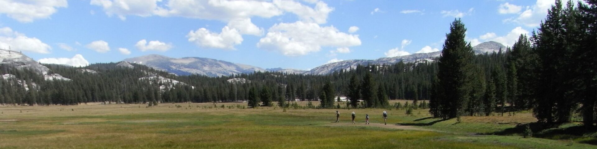
@Tuolumne Meadows
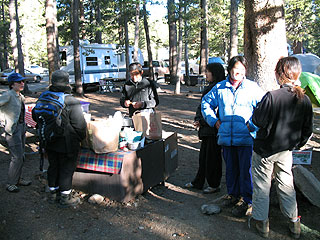
今朝、短い時間でしたが,TMキャンプ場でオフ会がありました。到着すぐさま、おいしいラテを作っていただきました。前日には掲示板でもおなじみヤストさん(JMTバックパッキング帰り)に偶然会われたそうです。写真:左から、A、Rosemaryさん、西村さん夫妻、Kimiさん、Kobayashiさん。
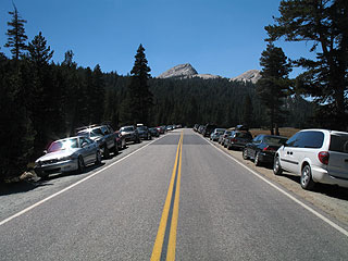
午後にはキャンプ場にはかなりの空きが目立ち始めましたが、TH(Cathedral Lakes)は満車でした。
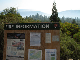
Boundary Fire
Webカムを見るとEl Capitan付近に煙が入っています。火事現場ははEL. Capitanの北西付近です。Tamarack Flat方面からEl. Capitanへのトレイル(旧Tioga トレイル)及びヨセミテクリークキャンプ場の南側トレイルは閉鎖しています。
Yosemite Fire Information Update #20
August 22, 2006
The Boundary Fire was discovered yesterday afternoon and is actively being suppressed by fire crews. The cause of this fire is still under investigation. Additional resources have been ordered including a Type 2 Interagency Management Team. Visitors and residents should expect to see and smell smoke from this fire throughout the park and in the surrounding communities. This fire is located less than 1 mile north of Ribbon Falls, 1/2 miles northwest of the summit of El Capitan and spreading north/northeast through the Blue Jay Creek drainage. The Boundary Fire is burning in red fir and currently totals 400 acres.
Due to the Boundary Fire the following trailheads to El Capitan are closed:
– The Old Big Oak Flat Road Trail from Tamarack Flat Campground east to Yosemite Creek Trail
– The Old Big Oak Flat Road trailhead at Foresta
– The Yosemite Creek Trail south of the Yosemite Creek Campground
– The Lukens Lake Trail south of Tioga Road
Visitors to park can still access Upper Yosemite Falls from Yosemite Valley
140号 再開通
予想よりかなり速く(条件付ですが)開通しました。あと2週間ほどで常時開通しそうです。Caltransはじめ工事関係者に敬意を表したいです。
Today, Friday August 18th there will be a ribbon cutting ceremony hosted by CALTRANS, 9:00 a.m., at the west bridge. Attendees will be able to cross to and from for the ceremony.
Starting at 1:00 p.m. on Friday August 18th Highway 140 will be open to traffic from 6:00 a.m. to 8:00 p.m. daily.
CALTRANS goal is to open the road 24 hours a day in 2 weeks.
During this interim period the road will be open from 6:00 a.m. to 8:00 p.m. with 10 minute intervals between green lights. Vehicles under 28 feet, bicycles and pedestrians will be allowed.
The “Ground Probe” slope stabilization radar is being used in conjunction with human backups during this period.Emergency traffic (ambulances, fire and police) will be allowed to go through at night during this interim period.
YARTS: YARTS commuters are advised that inbound runs will start 10 minutes earlier than the pre-slide schedule on Monday. Currently outbound runs will stay the same as the pre-slide schedule, so that the last outbound bus will cross the bridges at 7:45 p.m.
Watch for new local postings.
140号:2本目の橋架かる
朝夕共に、両方向の時間限定通行が可能ですが、観光用とは考えないほうがよいと思われます。
NPSより:
Highway 140 Information
Caltrans has changed the westbound caravan waiting location to Highway 140 opposite Cedar Lodge. The second bridge has been completed. Vehicle size is limited to 28 feet. No new schedule has been issued. Below is the current access schedule.
Hours of operation in the morning:
*Westbound traffic will leave at 5:30 a.m.
*Eastbound traffic will leave at 6:00 a.m.
Vehicles need to arrive and be in line before the scheduled leaving time or they will not be allowed to join the caravan.
Hours of operation in the evening:
*Westbound traffic will leave at 6:00 p.m.
*Eastbound traffic will leave at 6:30 p.m.
*Westbound traffic will leave at 7:00 p.m.
Vehicles need to arrive and be in line before the scheduled leaving time or they will not be allowed to join the caravan.
ヨセミテ3っの100周年
ヨセミテ国立公園には、3っの100周年記念があります。
[1] 1864年:ヨセミテ渓谷(及びMariposa Grove)がカリフォルニア州立公園になりました。
[2] 1890年:ヨセミテ渓谷を囲む一帯が国立公園になりました(渓谷、Mariposa Groveを除く)
[3] 1906年:ヨセミテ渓谷が連邦に返還され、国立公園となります(ほぼ現在の公園と同じになる)。
1906年8月には(公園長でもある)Benson少佐指揮下の第14騎兵隊がヨセミテ渓谷に移動し、現在のYosemite Lodge付近に本部を設営します。以後NPSが出来るまでの10年近く、公園のパトロールをすることになります。
今日のNPSニュースより
Yosemite Centennial Month – Did you know that Yosemite National Park has actually had three 100th anniversaries? The Yosemite Grant of 1864 gave the State of California control of Yosemite Valley and the Mariposa Grove “for public use, resort, and recreation….” The Yosemite Act of 1890 acted on John Muir’s suggestions to create a “Yosemite forest reservation”-soon changed to Yosemite National Park-surrounding the original Grant lands. A third act in 1906 provided for the Yosemite Grant’s return to the federal government. In August of that year, acting superintendent Major Harry Benson of the Fourteenth Cavalry established headquarters on the site of the present Yosemite Lodge, marking the beginning of a unified Yosemite National Park much like we know it today. (C. Palmer – 8/15/06)
Laurel Fire
Hetch-Hetchyの北にあるLaurel Lake付近の火事は8月9日には700エーカー以上に広がっています。
公園の北西部一帯はかなり視界が悪くなっています。7月27日の記事の写真と見比べてみてください。自然発火の火事なので、とりあえず放置しておくようです。Laurel、 Frog、Fallsの三地域を総称してFrog Complexと呼んでいます(写真撮影:13日朝)
May Lake HSC
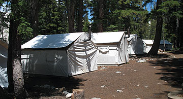
May Lake High Sierra Campはその名のとおりMay Lake湖岸(9,270ft))にあります。THからは約30分。傍にはBackpacker用のキャンプもあります。
DNCウエブサイトより:
May Lake (8 cabins, total occupancy 36) – Named for the wife of Charles Hoffman, the first man to climb the peak that now bears his name, Mt. Hoffman. Located on a quiet high mountain lake, perfect for relaxing, swimming and fishing. The easiest camp to get to via a short, but uphill 1 mile hike from the parking lot off Tioga Pass Road. May Lake is a great family destination! Elevation: 9,270 ft.
Tuolumne Peak (10,845ft.)
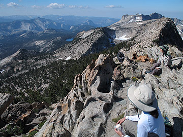
投稿者Kobayashi、toshi、+1の三名で、Tuolumne Peak登山、及びその裏側の探検をしてきました。
May Lake THの駐車場は満車状態でした。山の斜面の一部には、未だ雪が(少しでしたが)残っており、
ところどころ水が流れていました。また北西側の10,000ft.付近の小さな湖は、未だ雪に埋もれていました。写真はTuolumne Peakから見たヨセミテ渓谷(Clouds Rest, HD)、May Lake、Mt. Hoffmann方面。