“The Yosemite Marching Band”の存在を知りました。
YouTubeで見られます。
なかなか、スゴいです。
Snowshoe Trek
昨日(現地時間3月17日/土曜日)、Yosemite Association(Y.A.)が主催するOutdoor Adventureの「DEWEY POINT SNOWSHOE TREK」に参加してきました。今回のヨセミテ行のハイライト!。Badger Passスキー場を起点に、ヨセミテヴァレーを見下ろすDewey Pointまでの往復8マイルの雪上ハイキングです。
ヨセミテヴァレーはもうすっかり春の訪れでしたが、クルマで約30分Badger Passまで上がるとさすがに「まだ冬」という感じです。スキー場も4/1まで営業。
午前9時にここでガイドのKarenさん、そして私を含めて4名の参加者が集合。スノーシューを借りて出発です。
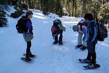
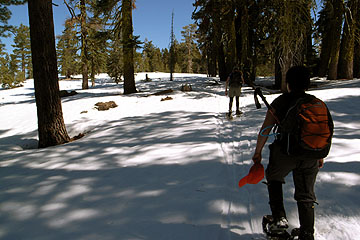
トレイルにはまだ数十センチくらいの積雪がありました。結構アップダウンがあり、スノーシューでも「健脚」クラスのコースです。またクロスカントリースキーヤーもたくさん入山していました。
天気は快晴で、運動量もありますから、ジャケットもフリースも脱いでしまいました。Tシャツになっている人もいました。
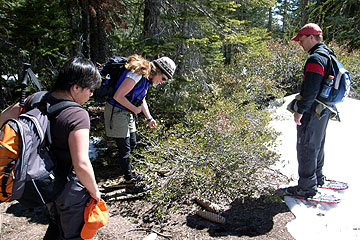
途中、何度も樹木や植物の観察、それからKarenによる自然解説があります。彼女はヨセミテには16年在住。Yosemite Instituteのインストラクターや夏の間はシーズナルレンジャーをするなど、経験豊富なナチュラリストです。
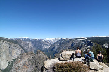
午後1時ようやくDEWEY POINTに到着。ここはエルキャピタンの真正面で、また遠くにはマウント・ホフマン、マウント・コネス、クラークレンジの山々が雪を頂いた姿を望めました。天気も最高でした。
今回初めて冬のアクティビティに参加しましたが、ヴァレーとは全く別の世界が広がっていました。
スノーシューやクロスカントリースキーをつけてトレイルに入るだけで、木々の様子、鳥のさえずり、遠くに望む景色などさまざまな自然の姿に出会い、またそのなかに自分がいるということのすばらしさを実感できます。
冬のまっただ中だと寒さで辛い日もあることでしょうが、3月の穏やかな天候の日はこうした活動に最適だと思います。
本日のヨセミテ
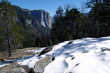
今日(現地時間3月16日)トンネルビューから、1.3マイル登った「インスピレーションポイント」まで行ってきました。
トレイル上の雪はほとんど消えていますが、上のほうではこれくらいの雪があったりします。
グレイシャーポイントまでの「4マイルトレイル」もほぼ同じような条件だと想像しますので、下の方ではまず雪はないものの、上の方ではまだトレイル上に残雪がみられると思います。お気をつけください。
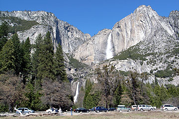
気温がかなり上がりました。ヴァレーでは摂氏23度くらい、ワワナでは27度くらいだったのではと思います。
ヨセミテ滝の水量が昨日よりも目に見えて増えていました。
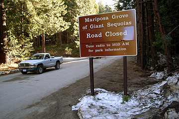
マリポサグローブへの道路はまだ閉鎖されていますが、南ゲート付近にもすでに雪はなく、この様子ではこちらのオープンも早いのではと思います。
本日のヨセミテ
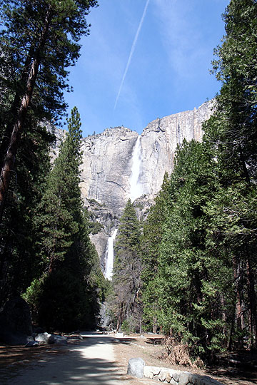
今日お昼(現地時間3月15日)にヴァレーに入りました。ヴァレーフロアにはほとんど雪がありません。日中の気温は摂氏20度前後でした。ジャケットも不要。(朝夕は冷えると思います。)
ヨセミテ・フォールの水量はほどほどにあります。この時期はビジターもクルマも少なく、ヴァレー内はとても静かです。
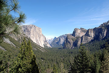
トンネル・ビューからです。雪はハーフドームの頭にはほんの少しだけ見えていますが、その奥のクラウズレストにはたっぷりありそうです。
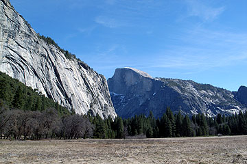
アワニーメドウからみたハーフドーム、ウェブカメラと同じ位置ですね。
草原にはもう雪は皆無です。もうしばらくすると、青々と茂ってくることでしょう。
関係者の話では今年はほんとに雪が少ないので、タイオガロードやグレイシャーポイントロードは5月中旬にはオープンするのではということでした。そして滝が枯れ上がるのもはやいかもしれません。
Tioga Road 除雪データ
新リンク
Tioga Road 開通・閉鎖日
除雪開始は4月17日より
TMの状況
Ski Conditions and Weather: It has been a very warm and dry week here at Tuolumne Meadows. Our afternoon highs the past three days have been in the low to mid sixties, with overnight lows barely reaching the teens. We have had no new snow, and our base is down to only 31 inches of snow. This is the shallowest snowpack in nearly 20 years here at Tuolumne Meadows; not since 1988, when there was only 29 inches of settled snow, has there been less snow on the ground on this date. There are more and more spots of open water along the Tuolumne River, and it definitely feels like spring. Ski touring is still very good however, with a nice firm base in most places making travel very easy for the most part. The weather forecast shows the warm and dry weather to continue for at least the next week.
Olmeted Point除雪ビデオ
Yosemite Time-Lapse
Yosemite の各所に設置された 3 つの webcam の画像を
動画にして配信している web サイトです。
http://www.halfdome.net
定期的に podcast 配信もしているので、iTunes などで購読手続きしておくと
自動で最新データを検索してダウンロードもできるので便利です。(無料)
3/5 の Glacier Point Movie (Sentinel Dome のカメラ映像) は楽しいです。
YOSEMITE THE GOLDEN AGE
patagoniaの2007春カタログでは「ヨセミテ黄金時代」と題して1960年代から現在に至るクライミングの歴史トピックが写真とともに紹介されていました。
オリジナルサイト「ヨセミテ:黄金時代」でも、クライマーのコメントやスライドショーが閲覧できるようです。
California Geological Surveyのシエラネバダ調査:1863-1864年
1860年、カリフォルニア州政府は岩石、化石、土壌、鉱物資源、植性などの収集や、地図の作成を含む地質調査を目的とした組織California Geological Surveyを設立し、Yale大学出身のJosiah Dwight Whitneyをリーダーとし、William H. Brewer、William Ashburner、Charles Hoffmannといったメンバー[1]らが選ばれました。隊は1860年末から活動を開始しましたが、最初の2年は海岸沿いやサクラメント川沿いでの活動を中心とし、シエラネバダの調査を始めるのは、1863年の春も終わる頃でした。以下はBrewerの日記を中心に、ヨセミテ周辺での足跡を簡単にまとめたものです。

地図:California Geological Survey、1863年夏のヨセミテ調査ルート
1863年5月、南カリフォルニアのTejon Pass方面(I-5、LAの北50マイル)での調査を終えたBrewerとHoffmannは、San Joaquin Valleyを北上し、Murphyの町(CA4沿い)でWhitneyと合流します。一行は近くにある発見されて10年ほどのCalaveras Grove[2]に行き、セコイアの巨木を観察します。このときWhitneyは、倒れていたセコイアの木の年輪を1225まで数えています。Brewerは伝わる話によると、大きな木々は倒れ、そのなかで”Father of the Forest”と呼ばれたものは、直径116ft.で、高さは400ft.あったと書いています。Murphyの町に戻った後は、金堀でにぎわうColumbia、Sonoraの町を経由し、いよいよヨセミテに向かいます。途中立ち寄ったBig Oak Flatも金鉱で賑わう小さな村で、その名の由来は、昔生えていた直径10ft.の樫(Oak)の木にあると書きとめています。翌11日には、村の北にある近くの小高い丘から、雪を被ったシエラネバダ、Table Mountain(120号が108号から分岐する付近)、そしてSan Joaquin Valleyの西側の山々を見ています。
14日にはBig Oak Flatを出発し南方へ向かい、Merced Riverの北俣沿いでキャンプし、すぐ傍にある石灰岩質のBower’s Caveを見学します。いくつもの洞穴をこれまで見てきたBrewerですが、これがいちばん綺麗であると感想を述べています。15日はCoultervilleトレイルを使いBull Creek、Black’s Ranch、Deer Flatに沿って進み、Crane Flatに到着し、翌日にはTuolumne Groveの見学に出かけます。1週間前にCalaveras Groveを訪れたばかりだったためか、スケールの小さいここにはあまり感動していません。この先のトレイルはかなり荒れ始めます。いくつかの谷や尾根を越えて、突然渓谷が視界に入り始めます。
この日はBridal Veil Fallを越えた、Tu-tuc-a-nu-la(El Capitan)の麓にキャンプをします。

次の日はMerced Riverを対岸(南側)に渡り、Yosemite Fallsが真正面に見えるところまで行き、ベースキャンプを設営します。隊はこれから一週間ほどかけて、渓谷内の調査・測量を行うことになります。Brewerは、個々の滝や岩壁の形状や高度についての、詳細な記述を中心とした渓谷の概要を書きまとめています。また余談として、キャンプ地の付近のMerced川の流れが強く、渡ろうとしたら馬の足がさらわれて川に落ちたこと、ヨセミテ滝を測量しようとして、Hoffmannと共に高度差3,000ft.もある横の谷(現在のトレイルのある谷)を6時間掛けて登り、そこからみる景色に感嘆したこと、この頃渓谷にはたった12人ほどの観光客しかいなかったことについて触れています。 ところで、California Geological Surveyの最初の報告書”Geology I”は1865年に作成されますが、その中でWhitneyは学術的な話題をそれ、ヨセミテ渓谷について2点ほど面白いことを書きとめています。一つは、渓谷へのアプローチのとり方です。最初に感動的な渓谷の全容を見たいのならば、Mariposaトレイルを使い、Inspiration Pointから渓谷にルートをとるべきであること、渓谷めぐりをして個々の景観の様子を知ったあと、最後に全容を見て感動するならば、Coultervilleトレイルから入り、Mariposaトレイルで渓谷を出るルートを進めています[3]。本人はそう書いてはいないものの、Coultervilleのトレイルは今ひとつと言った感じが伺えます。もう一つは、渓谷を訪れる最適の時期について触れ、5〜7月の水の多い満月の頃に訪れることを勧めています。水のない季節に来て大岩壁を見て感動し、水がなくて少し残念だったと思うのは大間違いで、最も感動する状況を逃していると強調しています。

6月23日、隊はいよいよヨセミテ渓谷を出発します。いったんColutervilleトレイルを西に戻り、途中でMonoトレイルに入り、この日はPorcupine Flatまで進みます。ここは標高8,850ft.のロッジポールパインの林に囲まれた小さな平地で、蚊がかなり多いと記しています。しかし、シエラの大展望があり、Whitneyはそれらを14,000ft.級の山々と思い込みかなり興奮したようです。翌日はその西側の尾根をたどり、標高11,000ft.ほどの山に初登頂します。これはメンバーの名前をとってMt. Hoffmannと名づけられました。周りには標高12,000ft.を越える山々が50ほど見られ、それらのほとんどは雪を抱いたり、急峻な岩壁を持つ花崗岩の岩峰であるとBrewerは記します。そしてスイスアルプスほどに綺麗ではないが、その広大な荒涼さが特徴であろうとしつつも、”The scene is one to be remembered for a lifetime”とその印象深さは一生ものであると書き残しています。6月25日にはTenaya Lake湖畔にキャンプをし、26日にはTuolumne MeadowsのSoda Springsに入ります。この日近くでトレイルの探査をするために近くでキャンプしていたパーティから、南軍がペンシルベニア州に侵入したことを知らされ、一行はかなり落ち込んだと記しています[4]。ともかくもこの日の夜は快晴で、月明かりに照らされ周辺の山々が美しい風景を作り出していました。

27日にはキャンプをMono Passから3マイル付近に移し、翌28日、調子の優れないWhitneyを残しHoffmannとBrewerはガレ岩、氷、雪を越えて標高13,000ft.強の山に登り、Mt. Hoffmann以上の大展望を得ることが出来ました。この山はアメリカの地質学者の名前をとって、Mt. Danaと命名されます。キャンプに戻ってきた二人の話しを聞いたWhitneyは自分も登ると決心し、翌日三人は、再びMt. Danaの頂を目指します。Hoffmannは別の峠[4]を観察し、其処にもトレイルが作れる可能性を示唆します[5]。Berwerは、Monoトレイルが、すでにシエラの東側で見つかっていた鉱山への補給のため、パックトレインが週一度の頻度で、山を越えていることを記しています。また周辺の山々には昔あったであろう氷河の形跡がいたるところにあることを書き記しています[6] 。 30日には再びSoda Springsに戻り、翌7月1日にはWhitneyとパッカーのJohnはBig Oak Flatへ向けて戻ります。一方HoffmannとBrewerの二人はTuolumne riverの上流に探査に向かいます。谷に道はなかったものの、この日は10.5マイルほど進み、平らな谷の行き止まりでキャンプをします。
 奥には13,000ft.を越える雪を抱いた花崗岩の山が、青空を背景に聳えたっていました。 ”It was most picturesque, wild, and grand. And what an experience!…” Brewerはかなりの量を割いて、そのキャンプ地一帯の美しさを書きとめています。
7月2日は早朝に行動を開始し、奥に見える最高峰を登りに出かけます。樹林帯をぬけ、昔氷河によって磨き上げられた岩の斜面を越え、あと高度差にして1,000ft.までに迫ります。そこからの斜面の雪は場所によっては柔らかく、2-3ftも潜り始めます。出発して7時間後、二人は頂上直下125〜150ft.に達するも突破できず、其処であきらめます。高度は13,000ft.付近を示していました。この山は、英国の地質学者の名を取り、Mt. Lyellと命名されます。
 翌日は朝遅くまで休んでから出発、ゆっくりとSoda Springsへ戻ってきます。7月4日、今度はTuolumne River沿いを数マイルほど下り、一帯の測量をします。Brewerは南に聳えるUnicornとCathedral Peakの二つの尖峰が特にすばらしく、まさに後者は巨大なCathedral(聖堂)のようだと書いています。あくる日は、二人はTuolumne Mewadowsの北にある岩峰[7]で最後の測量を済ませ、7日にはMono Lakeへと下りヨセミテ渓谷を出てから2週間にわたるテントなしでのヨセミテ・ハイシエラの駆け足の調査を終えました。

資料:
”Up and Down California in 1860-1864: The Journal of William H. Brewer” William H. Brewer(1930)/Univ. of California Pressより再版
”Geology, vol I. 1865”, J. D. Whitney(1865)
挿絵(”Geology, vol I. 1865”より):
1. Yosemite Valley (Fig. 62)
2. The Obelisk Group – from Porcupine Flat (PLATE IV)
3. Cathedral Peak Group – Upper Tuolumne Valley (PLATE VI)
4. Mount Lyell and the source of the Tuolumne River (PLATE VII)
5. Summit of Mount Lyell (Fig. 73)
6. Glacier Polished Surface in Tuolumne Valley (Fig. 72)
注釈:
[1]1860-1864年の間のメンバー:
Professor J. D. Whitney … State Geologist
Professor W. H. Brewer … Principle Assistant, 1860-64, in charge of Botanical Department
J. G. Cooper, M.D. … Zoologist, 1860-64
W. Ashburner … Assistant in the Department of Economical Geology, 1860-61
C. F. Hoffmann … Principle Topographical Assistant, 1861-64
V. Wackenreuder … Topographical Assistant, 1862, 1863
W. M. Gabb … Palaeontologist, 1862-64
A. Remond … Volunteer Assistant in the Geological Field work, 1862, 1863
Clarence King … Volunteer Assistant in the Geological Field work, 1863-64
J. T. Gardiner … Volunteer Assistant in the Topographical Field work, 1864
C. Averill … Clerk, Comissary and Barometrical Observer, 1860-63
[2] 1852年に発見。
[3] Coulterville及びMariposaトレイルは、現在の車道CA120とWawona Rd.は全く別のところを通っていました。
[4] 当時は南北戦争の最中:6月3日、Lee将軍率いる南軍がペンシルベニア州に侵入、やがて7月上旬のGettysburgで敗北を喫する。
[5] Tioga Pass。
[6] Muirは1870年、シエラに氷河が現存する事を発見します。ヨセミテ・シエラの氷河は、形状だけを見れば万年雪渓のようなもので、ヨーロッパでの大氷河を見ている3人にとっては、氷河と考えるに到らなかったと思われます。
[7] Ragged Peak。
1863年8月、ヨセミテを越えたBrewerとHoffmannらは、Mono Lake南岸のクレーターや、カリフォルニア・ネバダ州境にある金で賑わう町Auroraを訪ねた後、Sonora Passを越えて、出発地点のMurphyの町へ戻ってきます。その後、Ebetts PassやCarson Passを越えるルート(現在のCA4、CA88号沿い)を調査し、Lake Tahoeを周り、Sqaw Valleyからシエラを西に越えて、San Franciscoへの帰路に着きました。途中Brewerは、Sacramento川を下る蒸気船の中で、一年前にYale大学を卒業し、東海岸からカリフォルニアへと旅をしてきたClarence King(後にUSGSの初代所長となる)とJames Gardnerに出会います。すぐさまKingは無償のアシスタントとして隊に参加し、Brewerと共に年末いっぱいまで、Lassen Peak登頂を含む、北カリフォルニアのCascadeやKalmath地方の調査をしました。冬の間、KingはHoffmann、Ashburnerらと共に、Olmstedが監督するマリポサの金鉱で地質調査の仕事をし、その合間を縫って近くの山に登ります。そのとき遥か南方に白い峰々を望み、カリフォルニアの最高峰が、当時考えられていたMt. Shastaではなく、南部にあるとの確信を得ます。翌年4月、ネバダ州の西部探査の際に、同行したKingからその話を聞いたWhitneyは、そのシエラネバダの地図の空白部へ調査隊を送る決断をします。

[横断ルート:5月~7月、下の▲はMt. Brewer。上はMt. Goddard]
1864年5月24日、Brewer、Hoffmann、King、Gardner、そしてCotterらはSan Franciscoを出発し、Visallia経由で6月10日にThomas’ Mill(現Kings Canyon NPのGeneral Grant Groveのすぐ西側)に到着しました。一行は、手配中の荷物が届くのを待つ間、周辺に生えるセコイアの調査を行います。木々の太さや高さは、巻尺や三角測量を使ってかなり正確に測られました。いちばん大きなセコイアは、根元付近の円周が106ft、.高さ276ft.もあるものでした。また、火事で焼け中空となったセコイアの倒木があり、それは馬に乗ったまま、20メートルほど奥に入ることが出来るほどの巨大なものでした。Brewerはすでに幾本かの小さなセコイアが伐採され、フェンスの材料にされていること、数年のうちにまた幾本が切られるかもしれないと書きとめています。偵察のために近くの山に登ると、東には、雪を抱くシエラネバダの険しい山々が見え、Brewerはその荒々しさはいまだかつて見たことが無く、はたしてたどり着けるであろうかと、心配しています。
荷物が届き、6月17日にはいよいよ東へ向けて出発します。進路はおおむねKaweahとKings水系を分ける分水嶺に沿うもので、途中には数百本ものセコイアが見られます。Big Meadowsで数泊した後、6月28日は分水嶺上に聳える11,000ft.の山に登り、それをMt. Sillmanと命名します。その後Kings水系側の谷に下り、Roaring Riverを越え7月1日には、とある沢にキャンプを設営します。翌日BrewerとHoffmannは、沢の奥に聳えるピラミッド状の山(Mt. Brewerと命名)に登り、13,000ft.級の山々の連なるシエラネバダの主稜がさらに東にあることを発見します。戻ってきたBrewerとHoffmannの話を聞いたKingとCotterは、その一つの山(Mt. Tyndallと命名)を登りに出かけ、無事初登頂を成し遂げました。5日後二人が戻ってくると一行はキャンプ地を引き払い、エスコートのためにVisalliaからやってきた兵士たちの待つBig Meadowsへと戻ります。7月12日、Brewerは痛む歯の治療のため、Kingに付き添われ一時Visalliaへと山を降ります。其処からKingは別行動をとり、Mt. Whitneyへの登頂を試みるものの失敗、その後単独でWawonaへ戻り、Brewerらの帰りを待つことになります。
治療を終え、16日にThomas’ Millに戻ったBrewerは、待っていた隊に合流し、翌日Kings渓谷へと向かいます。途中Owens Valleyからトレイルを作りながらKearsarge Passを越えてきた採鉱者らに出会い、シエラを越えるルートが開かれたことを知ります。18日に3000ft.の急斜面を下り渓谷の底に降り立ったBrewerは、川(South Fork Kings River)に鱒があふれんばかりに泳いでいたと記録しています。次の日は渓谷を上流に10マイルほど進み、川が二股に分かれるメドウ地帯にキャンプ地を定めました。Brewerはこの大渓谷の印象を、”Next to Yosemite, this is the grandest canyon I have ever seen. It much resembles Yosemite and almost rivals it”と、そのヨセミテに次ぐ大渓谷で、様相も似ていると表現します。

[Kings渓谷(South Fork)]
Hoffmann、Gardner、Brewerらが渓谷の南側を調査する間、兵士たちは、たった5マイルで4,000ft.も高度を稼ぐ急峻な北側の斜面を偵察し、Kings渓谷を抜け出すことが可能と思われるルートを発見します。一行はそれを辿り峠を越えて、次の測量地点として定めたMr. Goddardへと向かうべく、北側の渓谷Middle Fork Kings Canyonへの下降ルートを探し求めます。しかし、その急な斜面に荷物を持ったパックが通過が出来るルートは見つけることは出来ず、Kearsarge Passからのルートを使い、ひとたびシエラを東に越えて、北側から回りこみMt. Godderedを目指すことにします。Kings渓谷に戻った一行は、26日にBubbs Creek沿いのトレイルを辿り始めます。最初の1,500ftの斜面はかなり急で、所によっては馬やミュールを引っ張りあげなければなりませんでした。苦労をしながらこの日はBubbs Creek、Charlot Creek沿いに11マイルほど進み、翌日はKearsarge Passを越え、28日には灼熱のOwens Valley(Independence)に下りました。
![]()
[Middle Fork Kings River越しに望むMt. Goddard(左)]
一行は、Palisade(隊が命名)山群をはじめとする14,000?13,000ft.級のシエラネバダの山々を西に望みつつ、Owens Valleyを北上します。この間Brewerは、植物学が専門だけあって、Owens Valleyの植生についてきめ細かい観察を残しています。8月1日、隊は進路を西に変え、Rock Creekを辿り、8,000ft付近でキャンプをします。そして翌日、山陰の小さな谷を上り、雪と岩、そして砂に覆われた標高12,000ftの峠(Mono Pass)でシエラネバダの主稜線を越え、San Joaquin水系(Mono Creek)へと入ります。近くの尾根で一帯の偵察をした後、4日には谷を18マイルほど下り、Vermilion Valley(現在のLake Thomas A Edison付近)に到着しました。此処にベースキャンプを定め、隊は二つに分かれ、4人の兵士たちはシエラ西麓のFort Miller(現在はMillerton Lakeの湖底)へと食料調達に、残ったBrewerらは南側(Kings水系)からのアプローチに失敗したMt. Goddardを目指します。

[横断ルート:8月、▲はMt. Goddard]
馬で進んだBrewerたちは、9日標高10,000ft.、目指す山まであと7マイル付近と思われるところまで達します。翌朝は夜明けと共に徒歩で出発、標高11,000ft程度の岩尾根を乗り越えていきました(Le Conte Divideに沿って進んだと考えられています)。7番目の尾根を越えたときに見たのは、さらに6マイルも先に聳えるMt. Goddardで、しかも二つの深い渓谷が間を隔てていました。すでに行動時間は9時間を越えており、HoffmannとBrewerはそこで断念し、引き返すことにします。Cotterと兵士のSprattはあきらめず、さらに進み続けましたが、ルートが見つけられず頂上まで300ft.を残したところで引き返すことになりました。そして夜通し歩き続け、翌日の午後、出発してから36時間をかけて、食べ物も切らし、馬を残したキャンプ地へと戻ってきました。ベースキャンプに戻り、数日間休養した後の8月15日、今度はSan Joaquin水系の北部探査に向けて隊は進みます。しかし以前から不調を訴えていたHoffmannの足の状況が悪化するにいたり、8月21日、調査を打ち切ることにします。そして8月23日、Clark’s Ranch(ワオナにあったGalen Clarkの経営する宿)に到着し、Olmsted、Ashburner、3週間前にMt. Whitneyの試登(失敗)を終えて戻っていたKingらと再会します。Brewerは、隊員の服はぼろぼろで、馬も傷つき、本人の体重は30ポンドほど減ったと、調査行の厳しさを書きとめています。Hoffmannの様態を見る間Brewerは、Olmstedと共にヨセミテに出かけます。渓谷からはMonoトレイルを使いMt. Danaを目指しましたが、Olmstedはあまり山歩きが得意ではなかったため、馬で行ける隣の山に登り、それをMt. Gibbsと命名しました。Brewerがヨセミテ旅行から帰ってきても、Hoffmannの様態は悪化する一方でした。そこで4人は、Hoffmannを医者に診せるため、担架を使いマリポサへ山越えし、そこから先はKingとCotterがStockton経由でSan Franciscoへ送り届けました。そして後を追うように、BrewerとGardnerもOlmstedと共にマリポサを去ります。

[”Geology Vol. I”に掲載されたBalloon Dome(Middle Fork San Joaquin River):Hoffmannのスケッチに基づく版画]
San Franciscoに戻ったBrewerは、Yale大学から教授職内定の手紙を受け取り、カリフォルニアを離れる決心をしました。4年間に渡るCalifornia Geological Surveyの仕事の間Brewerが廻った距離は、公共交通機関で4,440マイル、馬で7,564マイル、そして徒歩で3,101マイルの計15,105マイルでした。隊の1864年の活動は、たった3ヶ月半で広大なシエラネバダ山系(ヨセミテの南)の偵察的調査をするもので、時間、予算、人的にもかなり制約されたものでしたが、Kern Riverの水源を確認したこと、Great Western Divide(Kings及びKernの分水嶺)の位置を正しくつかんだこと、シエラネバダに残る氷河活動の跡を確認したこと、幾つもの地点の標高を測量・推定したことなどと、数多くの成果を残しました。
さて、Brewer一行がシエラの調査をしていた6月末、連邦政府はLincoln大統領のサインを得て、ヨセミテ渓谷とマリポサグローブを州の公園として譲渡する法案を通しました。カリフォルニア州では、年末に議会の開催が予定されており、公園の管理委員会メンバーに選ばれていたWhitneyは、それに間に合わせるべく、急ぎ公園の境界地図や報告書を作成する必要がありました。9月中旬San Franciscoに戻ってきたばかりのKing、Gardner、そしてCotterらはWhitneyの命を受け、急遽ヨセミテ渓谷へと向かう事になります。測量に残された時間は、冬の嵐が来て山が閉ざされてしまうまでの数ヶ月しかありませんでした。
資料:
”Up and Down California in 1860-1864: The Journal of William H. Brewer” William H. Brewer
”Geology, vol I. 1865”, J. D. Whitney
”Mountaineering in The Sierra Nevada”, Clarence King
”King of the 40th Parallel”, James Gregory Moore, Stanford Univ. Press
”Exploring The Highest Sierra” James G. Moore, Stanford Univ. Press
”History of The Sierra Nevada”, Francic P. Farquhar, Univ. of California Press
”Clarence King”, Thurman Wilkins, Univ. of New Mexico Press
Clarence KingとMt. Whitney
Eastern SierraのOwens ValleyにあるLone Pineの町の西に座すMt. Whitney(標高14,491ft.)は、アラスカを除く米国49州の最高峰として知られ、毎年多くのハイカーがその頂上に挑みます。この山は1864年California Geological Surveyによって遠方から初めて測量され、推定標高約15,000ft.の合衆国最高峰(アラスカ移譲は1867年)として記録されました。当時の測量隊メンバーであったClarence Kingは、南からアプローチし、登頂を試みましたが、頂上付近で敗退してしまいました。7年後、シエラネバダに立ち寄ったKingは、ついにこの山の初登頂を果たします。しかしその2年後、それが別の山であったことがわかります。Kingは急遽舞い戻り、真のMt. Whitneyを目指し、ついに9月17日、頂上に達しました。しかし時すでに遅く、山は数パーティが登った後でした。以下は、Clarence Kingを中心としたMt. Whitneyの測量と初登頂にまつわる興味深い話のまとめです。
Kearsarge Pass

写真:Kearsarge Pass北側斜面から望む南西方面Kings-Kern分水嶺の山並み(2枚張り合わせ写真)。
1864年夏、探鉱者のThomas Keoughらにより、インディアンが使っていたOwens ValleyとSouth Fork Kings Canyon(Kings渓谷)を結ぶKearsarge Pass(11,845ft.)を越えるルートにトレイルが作られました。7月末、South Fork Kings渓谷一帯を調査し終えたCalifornia Geological Survey(Whitney隊)のBrewer、Hoffmannらは、このトレイルを使いシエラの分水嶺を東側へ越えます。Owens Valleyを北上した一行は、Mono Pass(ヨセミテではなくLittle Lakes Valleyの奥の峠)で再びシエラを越え、西側Mt. Goddard周辺の調査を行なった後ワオナに集結、10月になるとClarence KingとRichard Cotterは、州立公園に指定されたばかりのヨセミテ渓谷へと入り、公園境界の測量を行うことになります。1873年及び1875年、友人と共にヨセミテからKings渓谷を訪れたMuir一行は、同様にKearsarge Passを越えてOwens Valleyに入ります。このときMuirはMt. Whitneyの登頂を3度試み、2度成功しました。Brewerは日記の中で(1864年7月27日)、Kearsarge Passからの風景を”the whole scene was one of sublime desolation”と、その荒涼さを書きとめています。一方Muirは、『The Mountains of California』(1894年)で、”Surpassing grandeur of scenery”と雄大さを指摘しています。両者の好みが分かれて興味深いところです。
前置きが長くなりましたが、Kearsarge Passからの景色は一見に値します。峠への上り口は標高9,200ft付近のOnion Valley THです。ここはIndependenceの町の395号と、Market Streetとの交差点からOnion Valley Roadを西に14マイル弱ほど進んだ行き止まりにあります。THからは、高度差約2,600ft.、片道5マイルの整備されたトレイルを、高度障害に注意してゆっくりと、途中の景色を楽しみながら数時間も歩けば峠にたどり着き、南シエラの荒々しい山並み、眼下に広がる深く削られた谷や、所々に散らばる青い湖を展望することが出来ます。余裕があれば、峠の北側の斜面をできるだけ上がってみましょう、登るほどに展望が開けます。

Kearsarge Pass:左側最高峰はMt. Brewer(13,570ft.)、右奥の谷はKings渓谷上流のBubbs Creek。

地図
